FEMA Flood Zone a: What Insurers and Property Owners Know
Learn about FEMA flood zone A and its impact on insurance requirements and property values in 2026.
Written by AI for Insurance
You're in the middle of a transaction, and the flood question lands at the worst possible time. The property looked clean on paper, the neighborhood felt ordinary, and then the map label comes back as FEMA Flood Zone A. That single designation can change the insurance conversation, trigger lender review, and force everyone to ask a harder question than “is it high risk?” namely, “high risk compared with what, and under which rules?”
That is the trap with Zone A. It's a regulatory label, but it's not a complete underwriting answer. FEMA treats it as part of the Special Flood Hazard Area, yet the map alone does not tell you whether the building sits high enough, whether local ordinances are stricter, or whether a lender will require coverage on that specific loan. The right read is operational, not just geographic.
Table of Contents
- Why FEMA Flood Zone A Matters for Insurers and Owners
- How FEMA Defines Flood Zone A
- Why Zone A Is Approximate and What the Map Leaves Out
- NFIP Construction and Elevation Standards in Zone A
- How Zone A Drives NFIP and Private Flood Premium
- Mandatory Purchase Requirements, Lenders, and Escrow
- Using Zone A Data in Underwriting and Cat Modelling
- What Zone A Does Not Tell You and How to Probe Further
- Quick Comparison of Zone A with AE, AH, AO, and X
- Verifying Zone Status and Required Documents
- Practical Takeaways for Policyholders, Agents, and Carriers
Why FEMA Flood Zone A Matters for Insurers and Owners
A buyer gets to underwriting, the house appraises fine, and then the flood map says Zone A. The owner wants a straight answer about cost and compliance, but the first thing a senior analyst notices is that Zone A changes the workflow, not just the label. It tells the carrier to check elevation, the lender to check mandatory purchase rules, and the owner to check whether the building would still satisfy local floodplain standards if the file were reviewed tomorrow.
The practical stakes come first
For insurers, Zone A often means more than “high risk.” It can mean a request for an elevation certificate, a closer read on finished-floor height, and a review of whether the parcel sits in an approximate SFHA where the map does not carry all the details needed for a clean rate decision. FEMA's homeowner guidance points users to the official Flood Map Service Center and the community FIRM or FIRMette for the exact designation, because a label in isolation is not enough to determine what binding, pricing, or compliance step comes next (FEMA homeowner guidance).
For owners, the issue is timing. A renewal can become a documentation event. A purchase can become a lender review. A portfolio review can uncover that two buildings with the same map code need different underwriting paths because the local grade, drainage, or finished-floor height is different. In other words, Zone A is where the map starts, not where the decision ends.
Practical rule: if a file lands in Zone A, treat it as a request for more property data, not a final answer.
That's why the best analysts do not stop at the zone letter. They ask what the map omitted, which documents can fill the gap, and which rule set, FEMA, lender, or local ordinance, controls the outcome.
How FEMA Defines Flood Zone A
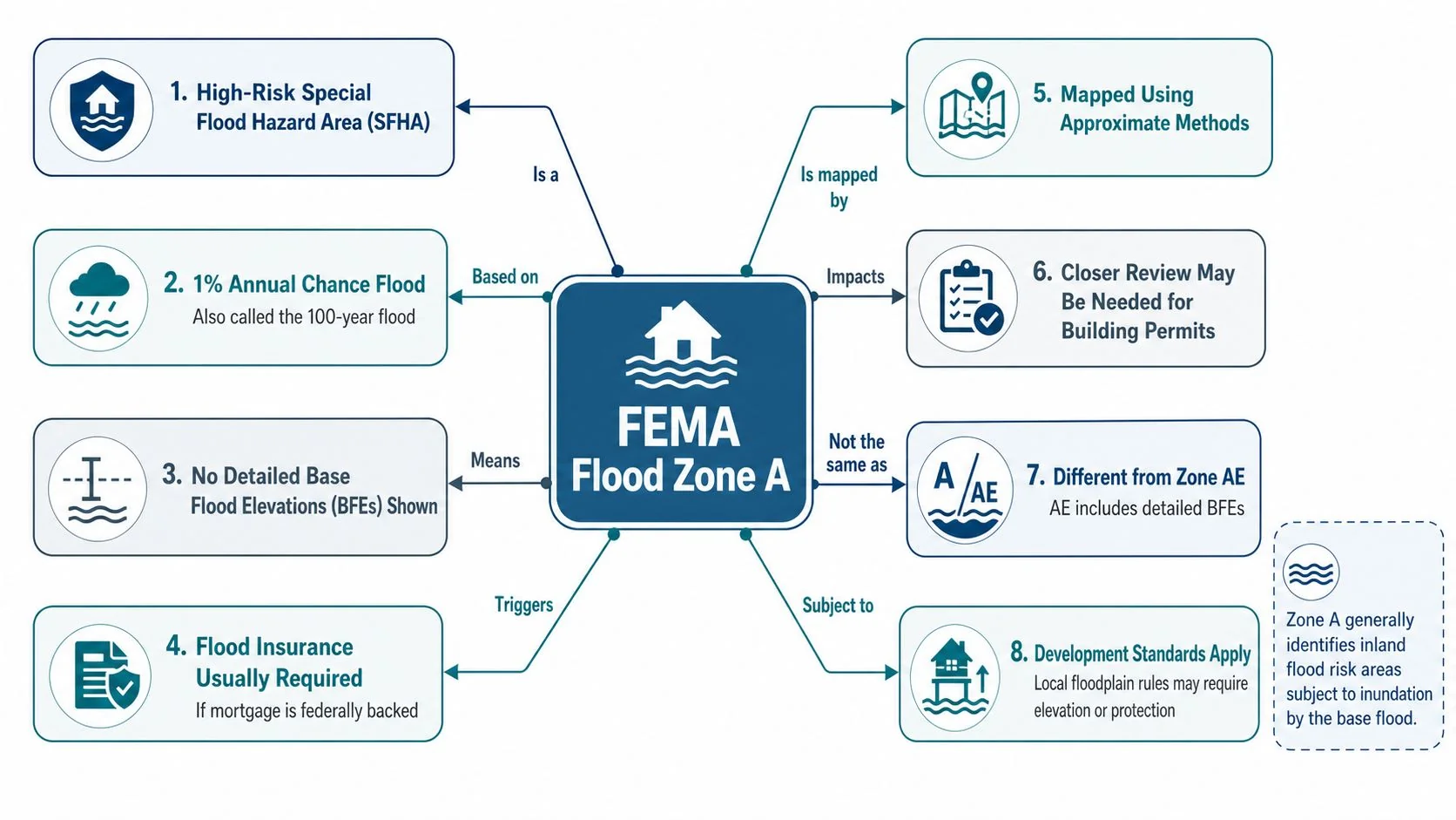
A house in Zone A sits inside FEMA's broader Special Flood Hazard Area, the category of mapped high-risk floodplain land marked by A or V on flood maps. FEMA's homeowner guidance ties those zones to an annual flood chance of about 1%. The familiar phrase “100-year flood” is shorthand for that single-year probability, not a promise that flooding happens once every century on a schedule.
What the letter really means
Within FEMA's A-zone family, Zone A appears alongside variants such as AE, AH, AO, AR, and A99. The shared label says the property is in a high-risk mapped floodplain, but the engineering detail differs by subtype. Underwriters, lenders, and building officials therefore do more than confirm that a parcel is “in an A zone.” They also ask which A zone applies, and what evidence supports that designation.
The important point is that Zone A is an approximate SFHA. FEMA's guidance describes it as flood hazard land where detailed hydraulic analyses have not been completed, so the map often does not show a base flood elevation or flood depth the way a more fully studied zone might (First Street Help Center on FEMA flood zones). That missing BFE is not a small technical gap. It changes how communities read the map, how builders document compliance, and how an analyst tests whether the building's actual elevation supports the assumed risk.
That is where the difference between two similar properties becomes operational. Two homes can sit inside the same Zone A polygon and still produce different underwriting outcomes if one has a higher finished floor, a different grade, or local drainage that changes exposure. An elevation certificate can confirm those differences, while lender overlays and local floodplain ordinances can still push the file toward a stricter review than the map label alone suggests.
Read the label as a probability signal, not a schedule
Zone A is probability-based. The map places the area inside the high-risk floodplain framework, but it does not tell you when flooding will happen, how deep water may reach at the lot line, or how two nearby buildings will compare. That is why the right question is not just what zone appears on the FIRM. It is what kind of Zone A file this is, what documents are available, and which rule set, FEMA, lender, or local ordinance, will control the decision.
Why Zone A Is Approximate and What the Map Leaves Out
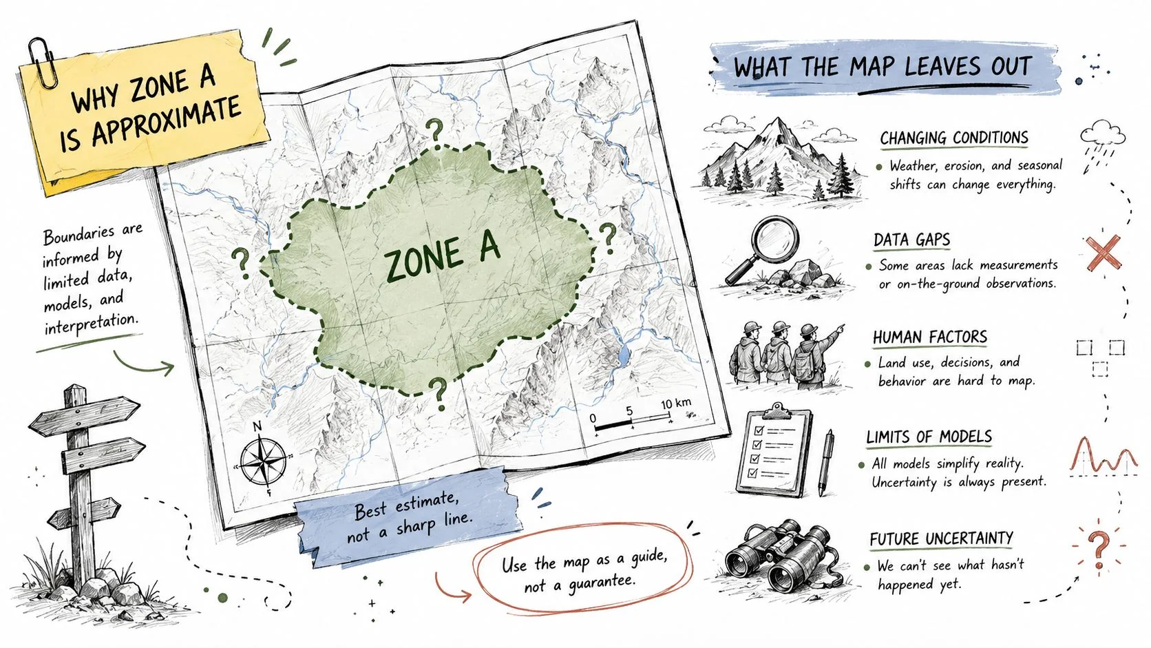
Zone A is one of the clearest examples of why a flood map is a starting point, not a final engineering opinion. FEMA's approximate-zone guidance says the area represents floodplain land where detailed hydraulic analysis has not been completed, and the official map often leaves out BFEs and flood depths. That means the FIRM gives you the zone, but not the full elevation story the way a more studied panel might (First Street Help Center on FEMA flood zones).
That missing detail matters because two parcels can sit inside the same Zone A polygon and still behave very differently. One lot may sit near a drainage swale, another may be shielded by grading, and a third may shed runoff in a way the map does not reveal. FEMA's own Zone A development guidance points to site-specific hydrology, cross sections, roughness assumptions, and field surveys as part of the process, which is another way of saying the map label does not finish the analysis.
The underwriting implication is straightforward. If the BFE is absent, you do not know enough yet to assume equivalent risk across the block. The correct next step is to test the parcel against local conditions, not to treat the Zone A tag as a complete loss-cost estimate.
<iframe width="100%" style="aspect-ratio: 16 / 9;" src="https://www.youtube.com/embed/oon_iXMJ9k4" frameborder="0" allow="autoplay; encrypted-media" allowfullscreen></iframe>
Why two identical labels can hide different exposures
A consumer-facing explanation often stops at “high risk, 1% annual chance.” That's true, but incomplete. Underwriting and cat modeling need the part that consumer explainers skip, namely the uncertainty around terrain, drainage, watershed conditions, and local hydrology. Those factors drive how fast water reaches the structure, whether it ponds, and how severe losses become once water enters the building.
For that reason, Zone A should trigger a local-data review. A parcel-level elevation check, a drainage review, and any available field survey can help distinguish a routine mapped floodplain file from one that carries a more complex exposure profile. A strong Zone A workflow asks what the map left out before it asks for a premium.
NFIP Construction and Elevation Standards in Zone A
A Zone A label does not end the compliance review. It starts a building-level check of floor height requirements, because FEMA's NFIP standards look at how the structure sits relative to the flood hazard, not just how the map colors the parcel. For new construction and substantial improvements of residential structures, FEMA guidance requires the lowest floor to meet the community's specified depth number, or, if no depth number is shown, to be at least 2 feet above the highest adjacent grade. That is the standard an inspector, floodplain administrator, or underwriter will apply when the file is reviewed (NFIP guidance, Unit 5).
A property that looks similar on a FIRM can still end up in a different underwriting bucket once the elevation evidence is reviewed. One house may clear the standard because its lowest floor is high enough, while another, across the street, may need corrective work or a different rating treatment because the file shows a lower benchmark. The zone label is the same. The compliance result is not.
Residential and nonresidential paths are not the same
For nonresidential structures, FEMA allows dry floodproofing to meet the same benchmark. That gives owners a compliance path that does not depend only on raising the finished floor, but it does not produce the same rating treatment as a raised structure. FEMA notes that insurance rating effectively subtracts 1 foot from floodproofed elevation, so a building generally needs to be floodproofed to 1 foot above BFE to rate like a raised building at BFE (NFIP guidance, Unit 5).
The operational consequence is easy to miss. A file can satisfy the floodplain rule and still produce a different premium because the rating engine applies a separate adjustment. That is why a building that is compliant on paper may still not price like a structurally raised property. Owners and agents get tripped up when they treat code compliance as the same thing as rating parity.
For a closer look at how automation is changing flood-risk workflows, see this case study on flood prediction model deployment, which is relevant to how insurers organize large volumes of location data.
Practical rule: compliance and rating are related, but they are not the same calculation.
The correct reading of Zone A construction standards is straightforward. First, identify whether the structure is residential or nonresidential. Then check whether the zone record includes a depth number. After that, verify the lowest floor or floodproofed elevation against the NFIP benchmark. Each step changes the underwriting file in a way the map label alone cannot capture.
How Zone A Drives NFIP and Private Flood Premium
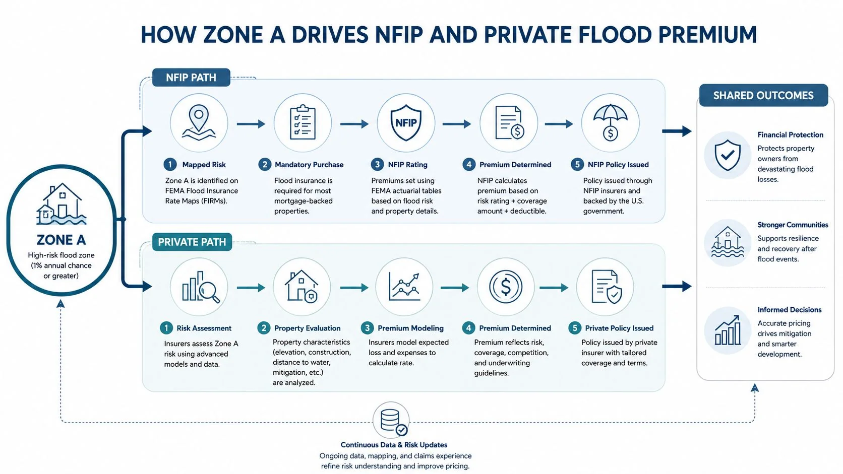
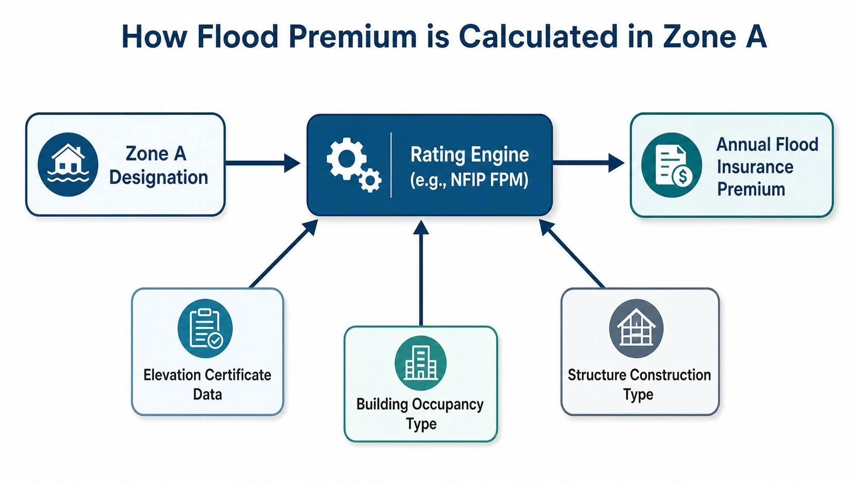
Zone A affects premium because it changes the inputs the rating engine must digest. The map label puts the property into a higher-risk workflow, then the insurer tests the building against the information that drives the rate, especially elevation certificate data, occupancy, and construction type. In FEMA-style logic, the difference between two similar houses often comes down to what the file proves, not just what the map says.
What an underwriter should verify first
An elevation certificate is only useful if the data on it is clean and complete. The key checks are the lowest floor elevation, the relationship between the structure and the adjacent grade, whether machinery or service equipment sits below the rated benchmark, and whether any enclosure is being used in a way that changes the exposure. If those fields are wrong, the premium can be misaligned with the building's actual flood position.
The same is true for construction type. A slab, pier, or other foundation configuration changes how the building responds when water enters the site. Occupancy matters because the rating engine treats a home differently from a nonresidential building. Zone A does not erase those differences, it just raises the importance of checking them carefully.
The most useful way to think about pricing is as a sequence. The zone label establishes the hazard category. The elevation certificate refines the vertical exposure. The occupancy and structure type refine how losses develop. Then the policy form translates those inputs into a price.
Why private flood pricing still starts with the same file
Private flood markets can apply their own underwriting logic, but they still need the same parcel facts if they want a defensible rate. A clean Zone A file is not one where every insurer reaches the same answer. It is one where each carrier can trace the result back to the building data that supports it. That is why teams that invest in better property data usually get more stable decisions, even when the final premium differs by market.
For a deeper process view of model deployment in flood-related workflows, see this insurance case study on flood prediction model operations.
Mandatory Purchase Requirements, Lenders, and Escrow
Zone A often gets treated like a flood-insurance rule by itself, but the trigger is more specific. Public guidance ties the mandatory purchase requirement to the mortgage and lender context, including federally backed financing and local rules, not to the FEMA zone label alone (NYC climate resiliency guidance). That distinction matters because owners and even some agents often flatten the two into one conversation.
What actually causes the compliance workflow
If a property is in an SFHA and the loan structure brings a lender obligation into play, the file can move into mandatory-purchase review. That review may be handled differently for federally backed loans than for conventional lending, and lenders can also impose their own overlays based on risk appetite or servicing policy. The Zone A label is the input, but the mortgage structure determines whether the insurance requirement becomes enforceable.
Escrow is part of the same compliance chain. When a loan requires insurance, the premium may be paid through escrow if the lender structures it that way, and that creates a different borrower experience than direct-pay coverage. If coverage lapses, the lender can also force-place insurance, which usually creates a much more stressful and expensive process for the borrower than proactive placement.
That's why a clean answer to “Do I need flood insurance in Zone A?” is usually incomplete. The better question is, “What kind of loan is this, what do the lender's overlays require, and how will that policy be administered over time?” The zone code starts the file, but the mortgage paperwork decides how the compliance machinery turns.
Using Zone A Data in Underwriting and Cat Modelling
Zone A is useful to an underwriter only if it gets joined to the parcel facts that the map cannot show. The working model is simple. Start with the FEMA polygon, then layer in parcel-level terrain, field elevation, claims history, and watershed context so the file reflects the structure rather than the neighborhood shorthand. That is the difference between a geographic label and a risk decision.
A better workflow for file triage
A disciplined Zone A review usually moves in this order.
- Confirm the parcel location: Match the address to the community FIRM panel and the zone polygon before anything else.
- Check the finished-floor position: Compare the building's lowest floor against the local terrain and any available elevation evidence.
- Review drainage and grade: Small changes in surface drainage can make two nearby lots behave differently in the same storm.
- Look for prior loss signals: Claims history can show whether the map overstates or understates the parcel's actual experience.
- Read the local ordinance: Community rules can exceed NFIP minimums, which changes the compliance burden.
That workflow is especially important in Zone A because the map is approximate. Without a mapped BFE, modelers have to be careful not to treat the zone letter as if it carried all the vertical detail needed for rating. Parcel-level inputs are what keep the model from overgeneralizing.
For teams building underwriting controls around those signals, this underwriting resource is a useful reference point for structuring the data flow.
Analyst's note: a stronger Zone A model usually comes from better local data, not from forcing the map to answer questions it was never designed to answer.
The operational payoff is better rate adequacy and fewer surprises at binding. The more the file depends on verified elevation and local site context, the less likely it is that two apparently similar Zone A properties will be treated as interchangeable.
What Zone A Does Not Tell You and How to Probe Further
The biggest mistake with Zone A is assuming the label is the risk story. It isn't. The map tells you the property sits in an approximate high-risk floodplain, but it does not tell you whether the building is close to the flood source, whether the finished floor sits above local high-water behavior, or whether drainage infrastructure has changed the parcel's exposure over time.
Questions that separate good files from weak ones
Two Zone A properties can look identical on the FIRM and still belong in very different underwriting buckets. One may have a strong elevation profile and no prior losses. Another may sit lower than the adjacent grade, have a troublesome enclosure, and live under stricter local floodplain rules. That is why the analyst's job is to ask for the details the map omits.
The most useful probing questions are practical.
- Where is the finished floor relative to surrounding grade? That tells you far more than the zone code alone.
- Has the parcel had repeated flood-related claims? Prior loss patterns help distinguish exposure from mere map placement.
- Did local ordinances add requirements beyond NFIP minimums? Local building rules can change the compliance picture materially.
- Was there any substantial improvement history? That can affect how the file should be reviewed and what documentation should be requested.
- Does the site sit near drainage features or altered runoff paths? Small topographic changes matter in a flood event.
The same question applies to policy history. If the file shows prior subsidized coverage, post-FIRM construction, or repeated permit activity, that context can signal a more complex compliance and rating history than a plain Zone A label suggests. A careful reviewer should not bind or renew on the zone alone.
For a broader example of how richer data layers improve climate-related access decisions, see this case study on natural-language access to large climate datasets.
Quick Comparison of Zone A with AE, AH, AO, and X
| Zone | Hazard | Mapped BFE | Typical Depth | Primary Implication |
|---|---|---|---|---|
| A | High-risk inland floodplain, approximate mapping | Typically not shown | Typically not shown | Requires site-specific review because the map lacks full hydraulic detail |
| AE | High-risk floodplain with studied conditions | Shown | Shown or implied through studies | Clearer elevation benchmark for construction and rating |
| AH | Shallow flooding | Shown or derived | Depth-based | Depth matters directly for compliance and placement decisions |
| AO | Sheet flow on slopes | Usually not shown as a traditional BFE | Shallow depth conditions | Building elevation and flow path become the key issue |
| X | Moderate-to-low risk | Not applicable in the same way | Not typically used as a standard benchmark | Usually outside the SFHA, but still not flood-free |
Zone A and AE both sit inside the high-risk family, but they do not behave the same in an underwriting file. AE generally gives the analyst a more studied elevation reference, while Zone A often leaves the team to rely on local engineering and development standards. That difference is why the same house can be easier to rate in AE than in A, even though both are high-risk zones.
AH and AO are also floodplain labels, but they point to different flood behavior. AH is tied to shallow flooding, while AO addresses sheet flow on slopes. Zone X sits outside the high-risk family, but it still does not mean zero flood risk. The practical point is simple, the zone letter determines which rulebook you start with, and Zone A is the one most likely to require the most follow-up.
Verifying Zone Status and Required Documents
A property can sit on a map labeled Zone A and still land in a very different underwriting file depending on what the documents show. The first check is the FEMA Flood Map Service Center, where the address search, community FIRM, and FIRMette confirm the controlling panel and the current designation. A zone copied from a listing, disclosure, or old closing packet is only a reference point until it is matched to the active map.
The file should then be built around the records that change the rating and compliance outcome.
- Elevation certificate: Confirms elevation and key building details for underwriting.
- Deed or parcel record: Verifies the property identity against the map.
- Community FIRM panel number: Shows which map panel controls the location.
- Floodplain permit history: Helps identify prior compliance actions.
- Prior policy declarations: Useful for tracking coverage continuity and prior rating context.
A Letter of Map Amendment or Letter of Map Revision can change the parcel's treatment if the evidence supports it. That requires more than a belief that the map is wrong. Elevation evidence, survey support, and a clean parcel record need to line up before anyone rerates the file.
Two houses can look identical on a FIRM and still produce different results in the file. One may have an elevation certificate that supports a lower risk posture, while the other may be held to local floodplain standards, lender overlays, or permit history that tighten the decision. The Zone A label starts the review, but it does not finish it.
Keep the map, the certificate, and the permit record in the same file. If those three disagree, the zone label alone should not drive the decision.
Practical Takeaways for Policyholders, Agents, and Carriers
Policyholders should treat Zone A as a prompt to verify, not panic. Before purchase or renewal, ask for the elevation certificate, compare the floor height to local grade, and confirm whether the lender's rules or local ordinances add any requirements beyond the FEMA map. If the file lacks those basics, the price and compliance answer is still unfinished.
Agents should lead with documentation discipline. In a Zone A file, the most valuable service is not repeating the map label, it is getting the parcel facts in order, checking whether the lender is federally backed or otherwise overlaying flood requirements, and making sure the insured understands the difference between insurance need and mortgage condition. A clean file reduces surprises at closing and at renewal.
Carriers and reinsurers should use Zone A as a cue to sharpen parcel-level underwriting. The map is a useful screen, but the better risk signal comes from elevation, terrain, claims history, local ordinance review, and any engineering evidence that closes the gap between a polygon and a building. AI for Insurance keeps a searchable library of verified implementations and evidence-based workflows, which can help teams compare how better data handling changes operational decisions over time.
If you're handling a Zone A property this week, pull the map, request the elevation certificate, and check the lender and local ordinance context before you bind or renew. That's the fastest way to turn a confusing flood-zone label into a decision you can defend.
